One of the rationales I offer for walking battlefields is to get a sense of the lay of the land. While I can read a topo map and wield a compass, being on the ground provides a unique perspective. With my eye surveying the battlefield, battle accounts take on more depth. Walking the ground can provide insight into why a battle was fought in the way that it was.
My recent walk around the First Manassas battlefield was no exception. With a notion of refighting this battle in miniature, I tramped the ground to gain a better understanding of the battle and the relationship between time and distance.
Following are a few photos from my recent walk in May.
 |
| Looking north toward Henry House from Visitor Center. |
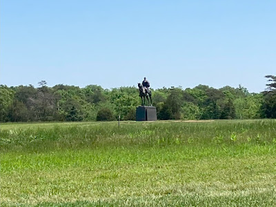 |
| Jackson, out standing in his field. |
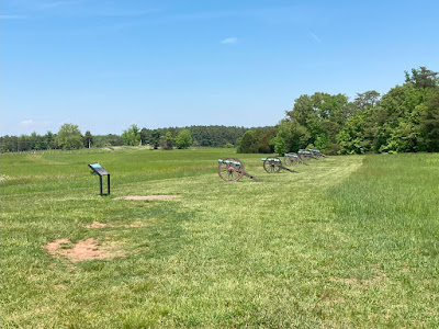 |
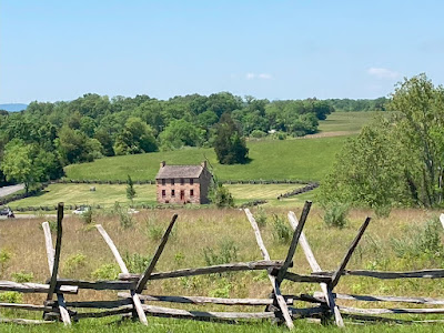
Confederate position on Henry House Hill
with Robinson House in background. |
 |
Looking west toward Henry House
from Confederate lines. |
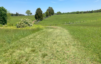 |
| The hills are not flat! |
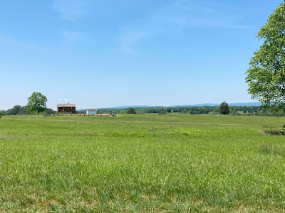
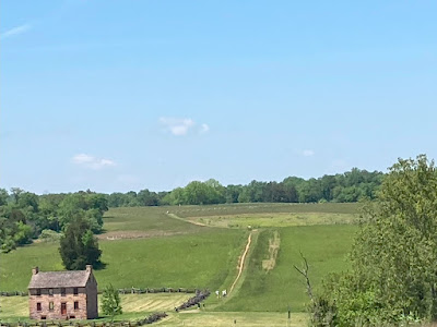 |
Stone House and Matthews Hill beyond
as seen from Robinson House. |
How do I use this information when I return home? I build a stylized battlefield in miniature for an upcoming series of games to refight this battle. |
Young's Branch Battlefield
on a grid |
Yes, this will be another grid-based game. Battle Briefings have been dispatched.


Great pics Jon - I love it.
ReplyDeleteThanks! Now you can have a mental picture in your mind when you fight over this ground.
DeleteI'd like to walk more battlefields, both here in the UK, but in Europe and the US too. It really does give you a much greater understanding of the movements and actions we read about in the history books etc.
ReplyDeleteLansdown Hill, an ECW site near us, is almost pancake flat, but there are small dips here and there, enough to hide troops for some of their movement. Then the final part where the action unfolded is just completely flat with not a jot of cover in sight, so you can see why the troops were reluctant to advance across it.
Hopefully, you will get that chance, Steve. To quote Yogi Berra, "You can observe a lot just by watching." While he was referring to baseball, walking a battlefield is no different.
DeleteInteresting to see some of the terrain I might be fighting over shortly. Was there more tree cover back then and was the surrounding land being actively farmed at the time? I ask because a lot of British battlefields have changed dramatically if not in topography then certainly in land use.
ReplyDeleteSeeing the terrain that you will fight-over adds a bit of a reality check into our games.
DeleteManassas battlefields became a national park in 1936 and has been maintained by the park service ever since. The park service attempts to keep the battlefield preserved as it was at the time of battle. Gettysburg has been undergoing a rolling restoration to return the landscape and sight lines back to 1863. While not developed, some of the vegetation has grown up on the battlefield.
Other ACW battlefields, especially some out west are not as well looked after.
Some nice pics of the Manassas battlefield Jon and as an aside, looks like you had great weather for your visit.
ReplyDeleteYour map looks lovely and should provide a challenging game, which I am looking forward to reading about soon.
Glad you liked the photos, Keith! Except for a day of drizzle at Antietam and Harper's Ferry, the weather was superb.
DeleteResearching battles and translating the battlefields to the gaming table brings great joy to me. Happy when I get a positive comment on the result!
Some great pics Jonathan, you can't beat the perspective you get from actually walking a battlefield. Look forward to seeing the game played out
ReplyDeleteThanks, Neil! You cannot beat the perspective offered by walking the ground yourself. I look forward to the game(s) as well. First game is on deck for Saturday.
DeleteBeautiful looking pics sir!
ReplyDeleteThanks, Michal!
DeleteI'd love a trip to the US, to visit this site and the many other battlefields. Your table layout looks top knotch as well.
ReplyDeleteSchedule a trip, Ray! You are probably closer to these battlefields than I! Glad you like the look of the table.
DeleteFine photos, one can easily imagine the vista filled with serried ranks of blue and grey. Your table looks great too.
ReplyDeleteThanks! we have the same imagination. I often wonder how I would attack or defend a piece of ground. Appreciate the thumbs-up on the table.
DeleteA very enjoyable roundup of the battlefield. I really like the way the cannon have been positioned to mark the Confederate position, a great idea. I have tried three times to get to Waterloo and even got as close as Brugge once, only to be frustrated each time. There is nothing like walking a battlefield to properly inform a table layout.
ReplyDeleteGlad you enjoyed the tour! You can also see the Federal battery positions near Henry House. When Federal batteries unlimbered there, the artillery commander commented that his guns would not be supported. He was right!
DeleteYou are so lucky to live in a country that looks after its battlefields. It's a constant struggle over here.
ReplyDeleteWell, we have lots of land, much was undeveloped, and was once cheap! We are fortunate to have these places preserved and well-maintained. The Visitors Centers are all very well done too.
DeleteGreat looking pics Jonathan and that battlefield is on my list of things to see.
ReplyDeleteChristopher
Thanks! Hope you make it to the battlefield one day.
DeleteHas the battlefield walks changed the way you approach creating the scenario?
ReplyDeleteWalking the ground may not have directly affected scenario development but it certainly molded how I thought about scenario development.
DeleteSome helpful pictures there that do show off the relationship between open space and wooded and presumably because the area got park status so early, at that time there was a very good idea of the original landscape and so we can assume it did look like that.
ReplyDeleteThe physical landform is also interesting, harder in tabletop games to get the ‘rolling’ type landscape right. Boardgames can manage it better and your hex conversion captures that.
For figure games, I have tried towels under the gaming mat and while it is visible to players, it never photographs well and just looks like a flat table.
Amusingly here in the UK, for a good chunk of my adult life, I have been wandering around the Bosworth (1485) battlefield, which is all laid out with a battle trail etc …. Until a few years ago, when luminaries decided the actual battle took place 2 miles further away, so I have spent many hours wandering the wrong fields …. apparently!
"Discovered" not "Decided". Decided sounds like they might move it again.
DeletePerhaps they might! Interpretation is an ongoing process. It had been interesting to read two recent books on the subject by Mike Ingram (Helion) and Christopher Gravett (Osprey) in which they accept the new location but disagree on the orientation of the forces ( one across the road and the other parallel to it, so an important 90 degree difference) and in which seemingly the fall of cannon type ball has not helped in that determination.
DeleteSome years ago, Peter Foss proposed a new site that was halfway between the old and new sites, but on the same axis. His view was based on topography, while the new site is based on finds …. Although not that many in truth, but certainly more than elsewhere :-)
Recent ‘time team’ work has tried to alter the axis of the Hastings battle, though the academic establishment seem resistant to that.
I think the best we can do is just go with whatever the current evidence points to. In some ways to the wargamer it doesn’t always matter. Wherever you put Hastings, on the table it will always be a ridge type feature with difficult terrain on the flanks and a small ‘bump’ of land out on the left (from the Norman perspective).
The whole Bosworth thing is a confusing affair, where exactly did Percy stand and where exactly did each of the Stanleys appear and act, seems a bit careless to lose so much valuable wargamer information in just 500 years :-)
Showing "helpful" pictures is one of the objectives gained by taking one of these battlefield walks. It also helps to put events into context and add a few data points into a wargamer's information set for later use.
DeleteThe use of hexes may not be to everyone's preference (I know some are vocal about it) but for me, hexes work. Hexes provide a pleasing visual to my eye and remove a lot of ambiguity. I think they speed play too especially for remote gaming.
As for Bosworth, I will let you and Graham wrangle over that battlefield.
Lovely…and useful… pictures Jonathan .
ReplyDeleteIt’s interesting to see how it has translated to the tabletop.
I am looking forward to seeing how the game plays out.
All the best. Aly.
Thank you, Aly! Different eyes can interpret differently. For now, this is my version.
DeleteGreat photos and it must have been interesting to walk across it all. A rolling landscape with its slightly hidden areas is always difficult to model.
ReplyDeleteBen, for me, walking a battlefield is always interesting and provides lasting memories. Sometimes, I treat rolling terrain as offering soft cover to all.
DeleteHi Jon, interesting pictures, and the model terrain looks great. I look forward to the game, thanks for inviting me!
ReplyDeleteThanks, David! Looking forward to seeing you take command on this battlefield.
DeleteACW battlefields are the best battlefields….
ReplyDeleteThanks for sharing the pics. 😀
You're welcome!
DeleteWill be good to see how the battle works out Jon. 1st Manassas is a nice battlefield to visit, 2nd Manassas I seem to remember is quite confusing.
ReplyDeleteYeah, I am hoping for an interesting battle too. 2nd Manassas is a bigger battlefield than the 1st with added confusion. Once gamed once or twice, 2nd Manassas becomes less confusing.
DeleteI find those pictures quite affecting. Beautiful rolling countryside, tinged with sadness because we know what happened there 160-odd years ago.
ReplyDeleteHo hum. Looking forward to the game next week!
Today, the place is tranquil and bucolic. Much different situation than witnessed in 1861. I look forward to the battle next week too! We will find out if you are a better McDowell than McDowell.
DeleteThat takes me back Jonathan...I walked that field back in September 1978.
ReplyDeleteMark, I vaguely recall having a booklet written by you on either First or Second Manassas. I ought to dig through my library and see if I can rediscover your work.
DeleteWhat really surprised me was how small an area the battlefield is and how close Ricketts' and Griffith's batteries were to Jackson's line.
DeleteI still have the text for those booklets, but all of the artwork for the maps is long lost...they were written back in 1992.
The short ranges on Henry Hill are surprising, indeed. This is especially evident when you consider that Federal guns were taking sniper fire from Henry House that was probably less than 50 yards away.
DeleteI have a large JR scenario which covers the entire battle, one of my favourites. I visited decades ago and your photographs do it justice, lovely area.
ReplyDeleteMy scenario covers the whole battle too. It would be fun to compare design notes some time. It is a lovely area, no doubt.
DeleteEnjoyed the pictures and comments. When taking students to Hastings, walking the site helped them appreciate the events of the battle better.
ReplyDeleteThanks, Richard! I would enjoy seeing your Hastings battlefield walk up on your blog.
DeleteNice pictures. I'm a big advocate of battlefield walking. It gives a whole new perspective that a map doesn't always convey.
ReplyDeleteGlad you enjoy the small selection of photos, Lee. We see battlefield walks in the same light.
DeleteI have been to many ACW battlefield sites in Virginia, Maryland, and of course Gettysburg, but have somehow never visited Manassas, so I enjoyed the photo tour. The resultant table looks interesting as well!
ReplyDeleteWith Manassas, you get two battles for the price of one!
DeleteMight I join in if you run it a second time? I picked up a Battles for Wargamers volume on the battle at Recon last month, and it does make me want to try. I'm hoping to get away with a Junior General reenactment of Fort Wagner for Juneteenth, and if it goes well I might try their First Bull Run scenario too.
ReplyDeleteYes but I need to find opponents in similar time zones
DeleteOnly saw this now. Definitely one on my bucket list, would love to tour ACW fields one day. They seem impeccably preserved (as should be) much unlike some in Europe unfortunately.
ReplyDeleteMike, if you get the chance, come over for a visit. Man6 of the ACW battlefields are very well preserved, indeed.
DeleteLovely pics! The first real and famous CSA victory of the Civil War, almost 5000 casualties appalled the nation - little did they realise those lost souls were just a drop in the bucket to come. :(
ReplyDeleteThank you! Yes, most figured the Rebellion would be over quickly. That was not to be.
Delete