Showing posts with label Battlefield Visit. Show all posts

Wednesday, May 31, 2023

A First Look at First Manassas

One of the rationales I offer for walking battlefields is to get a sense of the lay of the land.  While I can read a topo map and wield a compass, being on the ground provides a unique perspective.  With my eye surveying the battlefield, battle accounts take on more depth.  Walking the ground can provide insight into why a battle was fought in the way that it was.

My recent walk around the First Manassas battlefield was no exception.  With a notion of refighting this battle in miniature, I tramped the ground to gain a better understanding of the battle and the relationship between time and distance.

Following are a few photos from my recent walk in May. 
Looking north toward Henry House from Visitor Center.
Jackson, out standing in his field.
Confederate position on Henry House Hill
with Robinson House in background.

Looking west toward Henry House
from Confederate lines.
The hills are not flat!
Stone House and Matthews Hill beyond
as seen from Robinson House.
How do I use this information when I return home?  
I build a stylized battlefield in miniature for an upcoming series of games to refight this battle.
Young's Branch Battlefield
on a grid
Yes, this will be another grid-based game.  Battle Briefings have been dispatched. 

Tuesday, April 21, 2020

Eggmühl - A Battlefield Walk


April 21-22 marks the 211th anniversary of the battle of Eggmühl.  To commemorate this event, I dipped into past travel photos to refresh the memories from my visit.   

I visited Eggmühl as a half-day trip out of Regensburg (see A Stroll Around Regensburg) during our two week visit to Bavaria and the Tirol in May 2018.  Oh, the days of travel.  I remember them fondly.  Two trips have been cancelled thus far this Spring: one to Texas and one to Switzerland.  

Not interested in an early morning battlefield exploration and claiming she wanted to find a laundromat to wash some clothes, I left Nancy at the hotel and departed for Eggmühl on an early morning train.  While I do not remember the train timetable, I recall the trip being no more than 20 minutes from Regensburg train station to Eggmühl.  The train station itself is unattended with the town fire station backing up to the track.  
Not far from the station is the Lion Monument commemorating the 1809 battle.  Flanking both sides of the park are a series of placades describing both the operational aspects of the campaign and battle details.
 The informational markers include some useful maps to help me find my bearings.
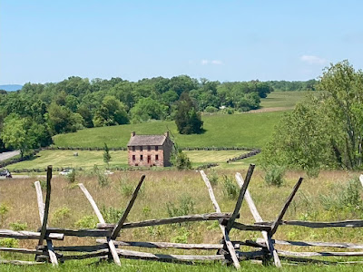
The train station and Lion Monument sit on high ground with the village of Eggmühl below in what was once the lowland water meadows.  Before I dropped down onto the road to Eggmühl, I surveyed my surroundings.  To the northwest, the white steeple of Unterlaichling can be seen beyond the treeline in the distance.  On the 22nd, St. Hilaire's division, led by the 10th Legere, attacked Austrian positions defending in Unterlaichling.
Unterlaichling in the distance
To the west, the spire of the church of Schierling can be seen.  Due to urban growth, the view to Eggmühl was obscured from my vantage point.  For a glimpse of Eggmühl, I would need to walk in a northeasterly direction along a narrow road through a minor industrial area. 
Schierling in the distance
The Vorberg
Bettelberg in the distance
On the way to the village I crossed over the bridge spanning the Gross Laaber.  While a modern bridge has replaced the 1809 bridge, it was this important crossing at which the Peterwardein Grenz put up a stiff resistance to early French attacks.  The grenz repulsed the first two assaults by Württemberg light infantry.  The third assault by the König Jägers successfully pushed the Austrians out.  Many of the remaining grenz were surrounded and captured in Eggmühl.
Gross Laaber looking east
Gross Laaber looking west
The Gross Laaber may not appear as a huge obstacle but the soft ground surrounding the stream and the muddy bottom likely presented a formidable barrier to attacking troops.

Having passed over the bridge, the road curves to the east and enters Eggmühl.  First into view is the church adjoining the imposing Schloss.  With onion-shaped spire, the church presents typical Bavarian architecture.
Schloss Eggmühl is now a retirement home.  From the outside, the chateau still dominates the landscape.  A steep earthen berm surrounds the southern approaches to the chateau.  The building, itself, is built upon a brick foundation rising above the water meadow.  
Schloss Eggmühl
The last building of note in the village is the inn.  While closed on my early morning visit, the building seems to house a restaurant and souvenir shop.  Adorned with murals, the inn definitely has the feel of a tourist destination. 
Eggmühl Inn
One end of the inn has the mural below marking this important event.  The painting depicts the meeting of Davout and Napoleon at the chateau.
With my walk of Eggmühl complete, I retraced my steps back to the train station.  On the way back, I paid a second visit to the Lion Monument before heading to the train platform.  
Lion Monument
After boarding the train, I selected a seat on the left side of the carriage so that I could focus on the expansive views of the rolling hills of the Vorberg and Bettleberg as they receded into the distance.  Back into Regensburg before noon and hungry, I had a chance to pick over the remaining morsels on the hotel's breakfast buffet.  This was a good day out.

Wednesday, December 11, 2013

Battlefield Walk - Mule Shoe at Spotsylvania

Three years ago, I visited a number of eastern American Civil War battlefields with a friend.  Before memories of those visits completely slip away, photos from those walks ought to be chronicled.  This time, I recall the Spotsylvania walk.  With this walk, I focus solely on the Mule Shoe salient and the Federal attacks on May 12, 1864.
Thure de Thulstrup's Battle of Spotsylvania

For an excellent account of the battle, I recommend, Rhea's The Battles for Spotsylvania Court House and the Road to Yellow Tavern May 7-12, 1864.

To gain a sense of the ground, below is a map of the Mule Shoe showing Confederate and Federal positions.
Mule Shoe Salient
Hancock attacked across the field towards the apex of the salient while Burnside attacked further down on the eastern side of the Mule Shoe.

I generally made my way from the western side around to the eastern side of the Mule Shoe.  The site of the attack on the Mule Shoe was crisscrossed several times to get each combatants' view of the terrain.  These wanderings are illustrated in the series of photos below.  Note the field is black in many of the photos.  Prior to my visit, the Park Service had control-burned off much vegetation covering the field between the two lines.  The burn adds both a sense of desolation and order to this portion of the battlefield.


This way to the Bloody Angle!
Looking east towards western side of Mule Shoe
Monument to 15 NJ
Monument to 49 NY
Monument to 126 OH
Monument to McGowan's BDE (Front)
Monument to McGowan's BDE (Back)
View from Mule Shoe looking towards Howard's attack approach
Federal trench line looking towards Mule Shoe

View from Federal trenches looking towards Mule Shoe
View Howard had as attack advanced across field towards Mule Shoe
Confederate trench on eastern side of Mule Shoe
Confederate trench line
Confederate trench embankment still nearly five feet in depth

Confederate position (left) along apex of Mule Shoe
Artillery piece on display at Mule Shoe

Wednesday, March 20, 2013

Battle of Port Republic - Walk

Reading Cozzen's Shenandoah 1862 reminded me of the rush through the Valley on my 2010 ACW battlefield barnstorming trip.  One of the stops during the 13-battle tour was in Port Republic.  Actually, the battlefield walk consisted of only a single stop and that was at the location of the 'Coaling' (coal hearth on the game map below from SPI's Jackson at the Crossroads) opposite 'Lewiston' or the Lewis mansion.  Much of the battlefield today is in private hands.
From the road looking up the hill, is the 'Coaling' as seen today.  The house at the top of the hill was built in 1886 by a member of the Lewis family and is clearly seen in the old photo of the Coaling in the placard below. 
"Coaling"

Placard provides a brief narrative of the battle
Federal guns of Clark and Robinson were deployed at the top of the hill and had a commanding view of the valley floor.  It was up this slope that Wheat's Louisianans under Taylor attacked out of the woods towards the Federal guns and the 66 Ohio.
Battle of Port Republic (source: Wikipedia)
The 'Coaling' anchored the Federal left with Tyler and Carroll deployed across the valley along today's Rt 708 to the South Fork of the Shenandoah. In the distance can be seen the building tops of Port Republic. The site of the Lewis mansion is in the middle ground. 
View from Coaling
Although the ground appears flat in the photo above, it is quite undulating and would have offered some protection to the combatants against long range artillery fire.  The photo below illustrates the ground undulations looking towards the Lewis mansion from the church.


Today, there is a small church at the base of the Coaling which doesn't appear on period maps.  Perhaps this building was added after the war?
Church at the Coaling
Reading Cozzen's account of the battle has piqued my interest to follow up with a more detailed accounting.  Having enjoyed Krick's work on Cedar Mountain, I'll give his Conquering the Valley a go.  After that, perhaps, a replay of Port Republic on the tabletop will be in order.  A quick glance at Conquering the Valley reveals that only casualty returns are listed.  No troop strengths for the battle, itself.  For troop strengths, I will have to rely on the game, Jackson at the Crossroads unless another source turns up.